
Gold Fields: A geospatial market intelligence platform
The Client
Gold Fields undertook a major shift in direction to accelerate growth by investing in greenfields opportunities.
The client chose to partner with Mechanical Rock in order to develop and deploy a "proof of concept" for a dynamic, data intelligence platform.
This platform required fully automated ingestion of industry-specific live and historical data sets to uncover key insights through geospatial data visualisation, mapping and predictive analytics.

The Challenge
In the mining sector, data plays a vital role in staying well-informed and competitive in the market, especially when looking at new strategic exploration opportunities.
However, the effort required to collate up to date competitor analysis, current market data, historical mining data and combine that effectively through a geospatial lens, is a major obstacle.
Mechanical Rock was tasked to build an automated, centralised data platform, ingesting company data, but also broadening the scope to focus on non-traditional data sources, such as social channels like Twitter or financial insights and share pricing via the ASX, all through a geospatial lens.
By reducing manual intervention and surfacing insights faster Gold Fields is able to react quicker and be the first to utilise new greenfields opportunities.
The Solution
A centralised ‘real-time’ data platform and dashboard that presents distinct perspectives on differing types of data and visualisation facilitates faster decision-making on potential new terrain or joint venture opportunities.
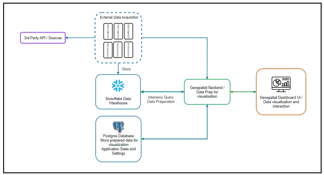
The work involved ingesting both proprietary company and nominated data sets into a Snowflake warehouse.
Our approach was to run all the compute intensive queries in Snowflake and populate the calculated results in a Postgres Aurora database for faster display and filtering using the power of AWS.
All data is available for visualisation using topographical and geospatial representations. The dashboard enables users to filter the displayed data based on various key metrics and is updated in real time, removing many hours of manual processes while enhancing accessibility to source data and insights.
More from our work


Data Platforms
Rio Tinto: Accelerating rail maintenance data processing with the RSM Scanner
Rio Tinto engaged Mechanical Rock to automate and accelerate the processing of paper-based maintenance work pack data using AI/ML learning, unlock data from historical archives and design a solution to meet their future data processing needs.


Product Development
Glove Boxx: AI-Powered Digital Asset Management Proof of Concept
Glove Boxx engaged Mechanical Rock to rapidly develop an AI-powered digital asset management solution to transform how vehicle and vessel owners track maintenance records and protect asset value.

Data Platforms
Mineral Resources: Databricks Lakehouse Implementation
Building a Unified and Scalable Data Platform to Empower Enterprise Analytics and AI at scale.